IELTS Listening · Listening Part 2
Lake Carrow National Park: map labelling
Plan, Map and Diagram Labelling practice, questions 11–16, with the transcript and every answer explained. Try the questions first; the answers are folded away below.
- Questions
- 11–16
- Transcript
- 474 words
- Level
- Harder
- Type
- Plan, Map and Diagram Labelling
The recording (transcript)
Listen first
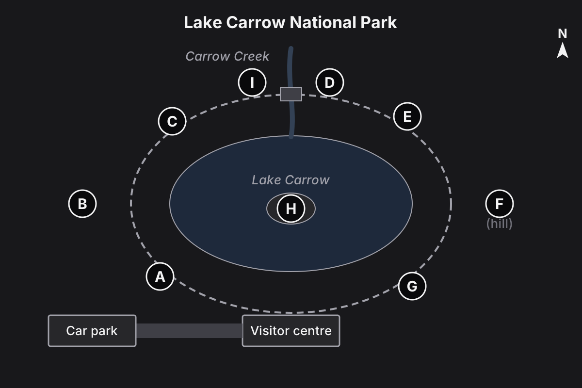
Ranger: Morning, everyone, and welcome to Lake Carrow National Park. I'm Dan, one of the rangers here. I'll be quick, because I know you're keen to get out on the track, but there are a few things you need to know about where everything is.
We're at the visitor centre, on the southern side of the lake. The walking track goes right round the lake and it's about six kilometres, so allow a couple of hours if you want to do the whole loop. It's mostly flat and well marked with yellow arrows, but some parts can be muddy after rain, so do stick to the track and keep an eye out for snakes on warm afternoons. I'd suggest you head off east from here and go round anticlockwise, because the views are better that way.
If you do, the first thing you'll come to, only about ten minutes from here, is the bird hide. It's right on the south-eastern shore. Do go quietly, because there are black swans nesting just in front of it at the moment.
Further on, on the eastern side of the lake, the lookout's worth the climb. It's not actually on the track, so you'll need to leave the track and walk up the hill on the eastern side, away from the water. From the top you can see right across the lake to the ranges, and on a clear day you can even make out the coast.
As you come round to the north-eastern part of the track, there's a sandy beach where you can swim in summer, although it's a bit cold for that today.
At the northern end, the track crosses Carrow Creek on a small footbridge. Just before you reach the bridge, on the eastern bank of the creek, there's the ranger's hut. You'll find one of us there most days if you need help. Then once you're over the bridge, on the western bank, you'll find the picnic ground, with tables and barbecues. It's a lovely spot for lunch.
Now, a lot of visitors ask about camping. The old camping area used to be on the north-western part of the track, but it's been closed so the bush there can recover. The new camping area is on the western side of the park, outside the loop track, away from the lake. Please don't camp anywhere else, because it disturbs the wildlife.
And then, as you come back round towards the visitor centre, on the south-western shore of the lake, you'll find the canoe launch. You can hire canoes here at the visitor centre and carry them down. The island in the middle of the lake is a bird sanctuary, though, so please don't land on it.
OK, the weather's meant to be fine all day, but take plenty of water. Have a great walk.
Questions 11–16
Label the map below. Choose the correct letter, A–I, for each place.
- AA
- BB
- CC
- DD
- EE
- FF
- GG
- HH
- II
- 11Bird hide
- 12Lookout
- 13Ranger's hut
- 14Picnic ground
- 15Camping area
- 16Canoe launch
Answers and explanations
Open one at a time to check as you go, or the key to mark them all.
Answer key: Questions 11–16Show
- 11G
- 12F
- 13D
- 14I
- 15B
- 16A
11Bird hideAnswer
Answer: G
Heading east from the visitor centre: “the first thing you'll come to … right on the south-eastern shore” = G.
12LookoutAnswer
Answer: F
“not actually on the track … walk up the hill on the eastern side, away from the water” = F, outside the loop. E is the swimming beach on the track.
13Ranger's hutAnswer
Answer: D
“Just before you reach the bridge, on the eastern bank of the creek” = D. Going anticlockwise you reach the east bank first.
14Picnic groundAnswer
Answer: I
“once you're over the bridge, on the western bank” = I. D, on the other bank, is the ranger's hut.
15Camping areaAnswer
Answer: B
The old camping area (C, north-west part of the track) is closed. The new one is “on the western side of the park, outside the loop track, away from the lake” = B.
16Canoe launchAnswer
Answer: A
“on the south-western shore of the lake” = A. H, the island, is a bird sanctuary.
More Plan, Map and Diagram Labelling practice
Common questions
Are these real IELTS Listening questions?
No. They're original practice questions written in the official IELTS format and numbering, with answers and explanations. Real test questions aren't published.
How should I use the answers?
Answer every question first, then check. For each one you got wrong, read the explanation and find the line in the transcript that gives the answer: that's where the trap or paraphrase is.
Can I hear the recording?
Yes: practice this question in the a2zexams app, where the recording plays (and later parts start where their questions are). This page shows the transcript so you can check every answer.
Hear it and answer in the app
See right and wrong at once with the reason for each, with the recording playing from where your questions start. Free to start, nothing to install.